This Highly Popular Trail In Europe Is Breathtaking, But It Has A Dangerous Secret
The Land of Fire and Ice, known for its unspoiled scenery and rugged landscape, is a vista of pure beauty from north to south. Iceland's hot springs and lava fields coincide with glacial cliffs and dramatic waterfalls underneath a dazzling display of dancing Northern Lights in this Nordic island country. With much of the land a vast canvas of untamed wilderness, road trips often take a backseat to hitchhiking and backpacking.
Located in southern Iceland, the walking route across Fimmvörðuháls is a tumultuous yet gasp-inducing trek that cuts through the heart of an ice valley. Wedged between the glacial cliffs of Eyjafjallajökull and Mýrdalsjökull, this popular trail guides travelers past 26 waterfalls, across a volcano, and along a dynamic plain of uncharted landscape. Navigating the trail from Skógar to Thórsmörk is not for the faint of heart or inexperienced mountaineers. While beautiful by nature, it's a dangerous journey with rapidly fluctuating weather conditions which can greatly reduce visibility, and unclear markers in various sections. Nevertheless, the trail unveils some of Iceland's captivating scenery at its peak.
Preparation is the key when embarking on the 15-mile journey across Iceland's often-unforgiving wilderness. Eight to 10 hours is the average completion time for crossing the Fimmvörðuháls pass, but this can vary greatly depending on speed and experience. Summer is the best time of year to embark on this hike, yet Iceland is known for its year-round chillier weather, with an average summer temperature of 55 degrees Fahrenheit.
From Skógafoss to the Baldvinsskáli Hut

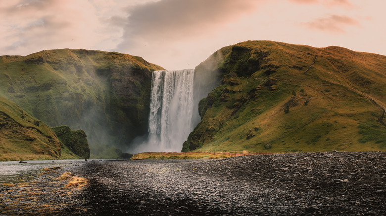
The journey along Fimmvörðuháls begins atop Skógafoss waterfall, an enamoring 197-foot tall waterfall framed on either side by misty moss and limestone. Along the first third of the trail, the path glides along emerald green plains, deep chasms, and a sea of waterfalls. Hikers encounter a subtle increase in elevation after crossing the Skoga River that's enough to make your breath come in faster waves. There's little to see beyond red soil and snow-capped peaks on the second part of this route. On the stretch to the lodging quarters, Baldvinsskáli Hut, evergreen plain fields give way to desolate territory littered with rocks.
It's possible to split this day hike into a two-day adventure by making an overnight reservation at this remote cabin. Even in the summer months, snow is always a possibility, given the high elevation and snowfields that are common along this section of the trail. Many hikers have lost their way trekking across the desolate land with thick fog and severe weather conditions creating a poor visibility range. It's this snowy landscape that makes Fimmvörðuháls one of the most dangerous hikes in Iceland. Rain and snow storms have even proved themselves to be fatal on this stretch, claiming the lives of at least three hikers, their memorials resting on a cairn fashioned along this stretch of trail.
Goðahraun to Thórsmörk

After nearly two miles, hikers will ascend up Goðahraun, a lava field whose volcanic eruptions formed the Magni and Móð mountains, a photo-worthy detour along this trail. The adjoining section of Fimmvörðuháls contains the most dangerous terrain on the hike, with a steep downhill incline to Thórsmörk.
Crossing Kattahryggur, also known as "The Cat's Spine," leads hikers along a narrow trail that clings to the edge of a deep cliff, with nothing but a thin link chain to grasp. While terrifying in the moment, the reward sitting on the other side is well worth the endeavor. A deep ravine clothed in emerald moss and patches of ice is reminiscent of scenes from the 2008 film, "Journey to the Center of the Earth." The final stretch down into this natural haven is an awe-inspiring vista and a picture-perfect way to end a road well traveled.